antonim@lemmy.dbzer0.com to 196@lemmy.blahaj.zoneEnglish · edit-21 month agoconclusions ruleimagemessage-square48linkfedilinkarrow-up1663arrow-down17file-text
arrow-up1656arrow-down1imageconclusions ruleantonim@lemmy.dbzer0.com to 196@lemmy.blahaj.zoneEnglish · edit-21 month agomessage-square48linkfedilinkfile-text
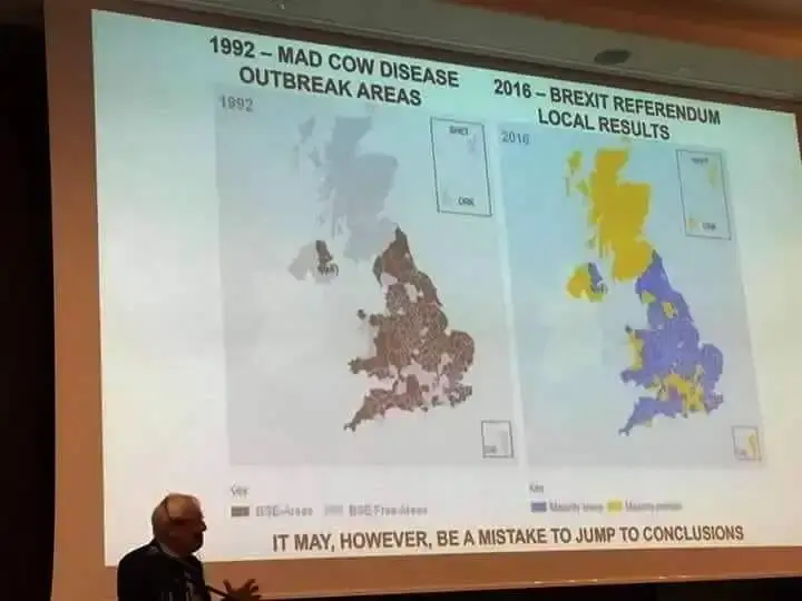
minus-squareBassman1805@lemmy.worldlinkfedilinkEnglisharrow-up17arrow-down1·1 month agoThe plot is an inverse of population density: rural areas have more exposure to cows, cities do not.
minus-squareFundMECFS@lemmy.blahaj.zonelinkfedilinkEnglisharrow-up14arrow-down3·1 month agoStill isn’t, otherwise the whole of scotland would be black since thats by far the most rural bit of the UK.
minus-squareScreamingFirehawk@feddit.uklinkfedilinkEnglisharrow-up8arrow-down1·1 month agoGiven the clear line at the Scottish border I would say that data is missing for Scotland
minus-squareMelodiousFunk@slrpnk.netlinkfedilinkEnglisharrow-up4·1 month agoThe grey is labeled BSE-free areas, though there’s enough jpeg in there to squint and make it say whatever.
minus-squareWeslee@lemmy.worldlinkfedilinkEnglisharrow-up4·1 month agoI don’t think so, Ireland is completely missing and NI is grey, like Scotland is

The plot is an inverse of population density: rural areas have more exposure to cows, cities do not.
Still isn’t, otherwise the whole of scotland would be black since thats by far the most rural bit of the UK.
Given the clear line at the Scottish border I would say that data is missing for Scotland
The grey is labeled BSE-free areas, though there’s enough jpeg in there to squint and make it say whatever.
I don’t think so, Ireland is completely missing and NI is grey, like Scotland is